A Vaccine for Partisanship
Jonas Salk invented the vaccine to prevent polio, Edward Jenner helped curb smallpox, and John Enders put the brakes on the measles. But it took Republicans and Democrats working together to inoculate against the scariest disease in politics — competition.
According to The Cook Political Report, only 18 of the 435 seats in the U.S. Congress are truly considered “tossups” and about 35 are considered “competitive.” In Oregon, just four or five out of 30 Senate seats and eight to 10 of the 60 House seats are considered competitive.
Like their colleagues in the science world, political scientists have for the past few decades perfected a way to inoculate themselves from competition in general elections. During a hearing on a bill to open Oregon’s primary to unaffiliated voters (it was sent to the trash bin … again), Rep. Alek Skarlatos (R-Winston) asked the poignant question of the day: “How do we make legislative districts more competitive?”
The answer, Representative, is blowin’ in the wind, and the wind direction is not likely to change. But the formula does exist.
Legislative redistricting is done by the legislators themselves once every 10 years. Over the years, they have mastered the art of drawing disfigured districts construed to corral the most registered voters of their own party as possible to make them safe in general elections. For example, my home is represented by a liberal, Rep. Tom Andersen (D-Salem). My neighbors across the street are represented by a conservative, Rep. Kevin Mannix (R-Salem).
The end result for most legislators is that the November election is just an exercise.
Is there a remedy? Perhaps. To find it, we have to go back to the 1950s when all this microscopic gerrymandering really took off. From statehood until 1952, legislators did not run in carefully crafted single member districts. They were assigned to counties and ran countywide.
In 1963, for example, Multnomah County elected five senators and 12 representatives. Lane County had two senators and three representatives. Lake, Crook, Deschutes, and Jefferson counties linked to have one state senator. Smaller counties were joined together along county lines and assigned senators and representatives. Come election time, voters would vote for multiple candidates to fill those assigned slots.
To win an election, candidates had to appeal to a broad swath of voters, not the partisan-knitted districts of today. The U.S. Supreme Court changed that in 1964 when it ruled on the “one person, one vote” standard. Districts could no longer have more representation than their population justified. A deviation more than 10% would clearly be declared unconstitutional, while less than a 5% deviation was more likely to survive a court challenge.
Oregon legislators decided matching counties together was no longer politically practical, so they created the process we know today of single-member districts. Greater population equalization was achieved, but Pandora’s Box was opened for partisan handiwork.
The state legislature subsequently passed additional criteria, but from a constitutional perspective the key elements were that districts must be as equal in population as possible, and contiguous.
Former Gov. Victor Atiyeh was one who regretted the move away from county lines to partisan-drawn districts. He would comment how, as a senator from the whole of Washington County, he had to give attention to the most rural residents’ interests as well as those adjoining the City of Portland.
Today, with most districts constructed for partisan benefit, it can be easy for a legislator to narrow their focus rather than the state as a whole. It is that narrowing of focus that some believe has helped expand the urban-rural divide.
It would take a magic wand to return to yesteryear. Fortunately, my pen can fulfill that purpose. It takes a lot of recalculations to blend the practice of the old with the requirements of the new, but alas, it can be done.
If you are on blood pressure medication or anxiety pills, take a deep breath. This is merely hypothetical and thus likely destined for the dustbin of history. But just imagine …

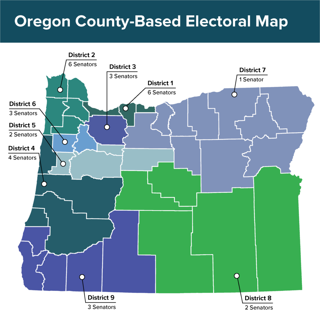
Oregon’s population is currently 4.27 million. Thirty state senators would need to represent close to 142,000 residents each. Two state representatives would be “nested” in each Senate district. County lines must be used whenever possible and must be contiguous, i.e. one sharing a border with another one. Not like today, where Multnomah County’s high concentration of Democratic voters are farmed out in pieces to neighboring counties to create more safe political districts, resulting in 10 of Oregon’s 30 senators now representing some portion of Multnomah County.
In the following map, Senate districts are reduced to nine with multiple senators elected in larger population districts to reach 30 in all, and a total of 60 representatives. All districts respect county lines except for Coos and Wasco counties, which are split between north and south, and the far eastern fringe of Marion County which is split off to join the district headed by Jefferson County to meet population equalization. The other 33 counties remain whole.
Urban and rural areas are in many cases joined together as well as east and west. Population deviation is only 3%. Senate districts at the high end represent 144,500 residents and 140,066 at the low end.
Candidates must run district wide. For example, four state senators are allocated to Lane, Douglas, Lincoln, and Coos counties. Candidates from Roseburg must appeal to voters in Eugene. Candidates in Eugene must appeal to voters in Roseburg and Lincoln City. If a candidate strays too far right or left, then poof! Just like yesterday’s paycheck, they’re gone.
Yes, the 2,500 residents of Jefferson County may not like being tied in with Benton County but consider the current congressional lines. Ashland, the liberal bastion on the southern western border by California, is represented by the same congressman as the folks in conservative Wallowa in the upper northern edge of the state. Congressional District 5 looks like a turkey leg and thigh, starting in the southeast of Portland, meandering down Clackamas and Marion counties, jaunting across the Cascades to Bend, down to Sunriver, and then back to the bottom of Linn County, within earshot of Eugene.
This hypothetical legislative map is much cleaner, and when evaluated along with other districts, rural Oregon will have more legislators carrying their voice than they do today.
Based on admittedly a back-of-the-napkin analysis from the last two general elections, the map will transform the Senate from five competitive districts to 20 or 21, and the House from nine or 10 competitive districts to 40-42.
If this was a Hallmark movie, it might happen. But politics is real life. Competition is not embraced. Partisanship is the only winner.

